WildCaster is the field application of the Wildcaster ecosystem: the tactical touchscreen tool that puts a
live, shared picture of a wildfire into the hands of everyone working it, from the coordinator in the
operations room to the crew leader on the line.
Drop a pin where a fire has started, or where you fear one will, and in seconds it draws the next 24 hours:
where the flames travel hour by hour, where the smoke drifts, and which schools, roads, power lines and
villages lie in their path. It runs on the phone or tablet a crew already carries, in a fire truck or command
vehicle on the ground and in a helicopter or spotter plane overhead, keeps working when the signal drops, and
keeps every device on the team looking at the same map.
The forecast where it is needed: in the hands of the crew, at the edge of the fire.
Three ideas sit at its centre.
One shared picture. Every fire, every team position, every report and countermeasure appears on a single common operating picture that all connected devices share and keep in step automatically. What one person marks, everyone sees.
It works where the fire is. The forecast is computed on the device itself, from data carried on board, so it runs with no command centre and no connection. Teams on the same local network share their picture directly, with no server and nothing to configure. The tool travels with the response, on the ground and in the air.
From command to the line. One tool serves a manager overseeing a whole region, a coordinator running an incident, and a field team on the ground, each seeing exactly the scope their role needs.
Oversees a region. Sees every team and incident beneath them.
↔
Coordinator~100 km
Runs the incident. Sees every team they direct.
↔
Field Team~50 km
Works the line. Sees own data and teammates' positions.
One shared common operating picture
Fire spreadSmokeTeam positionsReportsCountermeasuresImpact forecastEvent log
Bearers today: local network (offline, no server) and encrypted internet relay. On the roadmap: radio, LoRa and satellite.
One picture, shared and kept in step across every device, from the operations room to the fireline.
ForestFire.app
What you see, and what you do
WildCaster opens on a three-dimensional map of the real terrain, draped with satellite imagery from Europe's
Copernicus programme or a clean vector basemap. From there the work is direct and physical.
Start a fire. Touch the map to drop an ignition point, or paint an area for a fire already running. Add suppression lines where crews are holding. Press play.
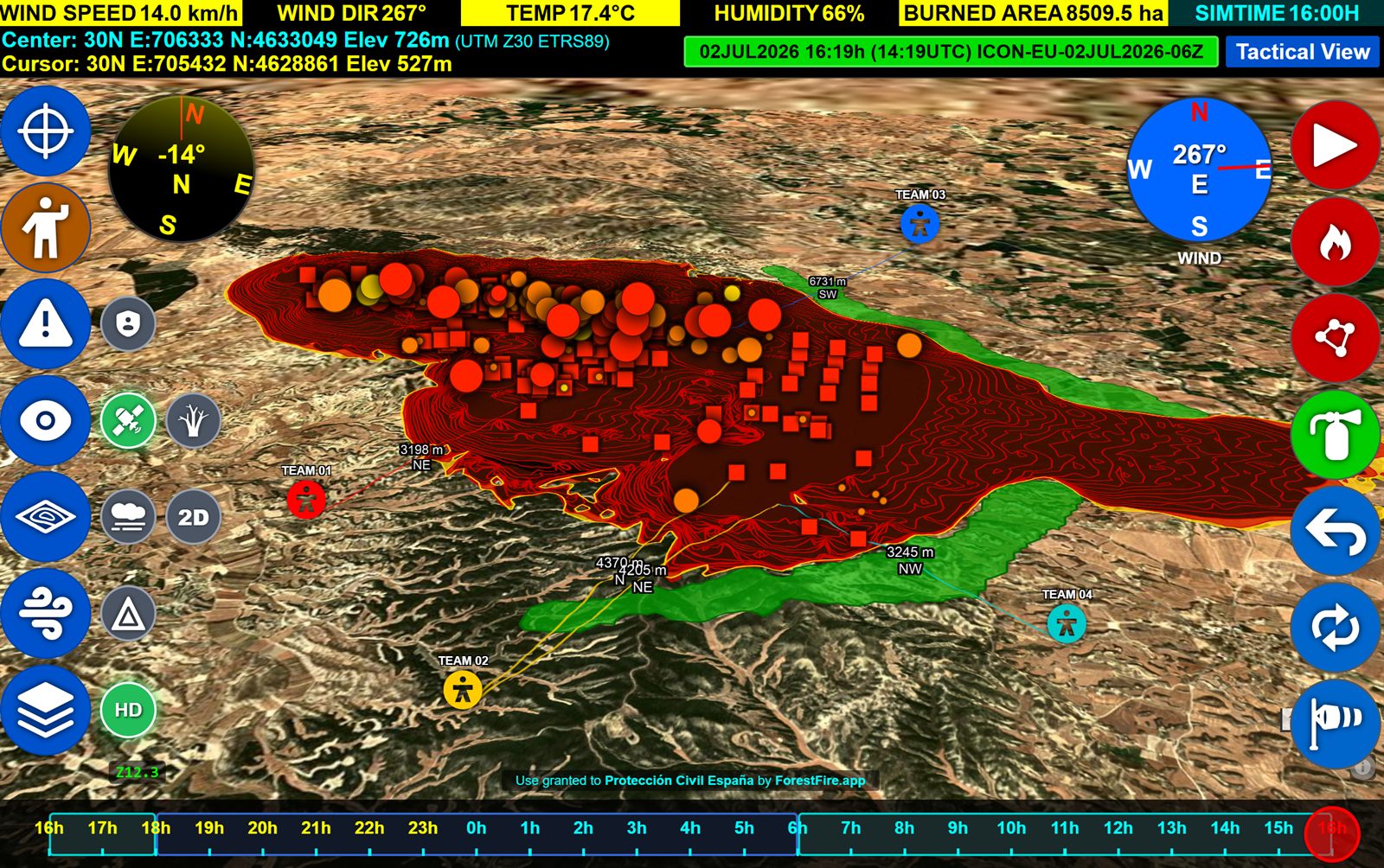
Watch it unfold. The fire grows across the landscape as hourly perimeters you can scrub back and forth in time. Alongside it the smoke plume spreads through the air, shaded into the same five air-quality bands the public sees in health alerts, from moderate to hazardous, and shown as flat contours or a true three-dimensional cloud.
See who is in the way. WildCaster carries a map of what is worth protecting: schools and hospitals, campsites and settlements, power, water, transport and industry, and protected nature. As the fire advances, the points it will reach light up in order of arrival, each with the time you have before it gets there. This impact forecast is what turns a spread map into a decision.
See your team. Live positions, fixed by satellite navigation including Europe's own Galileo and EGNOS systems, the distance from each team to the fire, and the reports and countermeasures they have logged all appear on the same map, shared across the team.
Read the weather and the danger. Wind arrows show speed and direction across the area, and fire-weather and fire-danger layers show where conditions are worst. Live hotspot detections from the VIIRS, MODIS and EFFIS satellite services can be overlaid whenever a connection is available.
Every control is built for a gloved thumb on a bright, shaking screen: large targets, a clear time bar, a
transparency dial to see the ground beneath the fire, and safeguards such as a three-second long-press to clear
the map so nothing is wiped by accident.
The tactical view: fire spread, teams, weather and the 24-hour timeline on one screen.
One team, one picture
This is what separates WildCaster from a forecast on a single screen. Every device on the team holds a copy of
the same operating picture, and the copies keep themselves in step automatically. The technique underneath is a
conflict-free replicated data type, the same family of technology that keeps collaborative documents consistent
across the world, applied here to a live incident. Two people can mark the map at the same moment, on different
devices, with no central server deciding who wins, and both edits survive and merge cleanly.
It is built for the conditions crews actually face. On a shared local network, an incident Wi-Fi, a vehicle
hotspot or a deployed access point, devices find each other and share their picture directly, with no server and
no setup. When the internet is available, distant devices join the same picture through a relay that only ever
sees encrypted data. Everything is end-to-end encrypted, every entry is cryptographically signed by its author,
and the whole history is kept in a tamper-evident log, so the record of who marked what, and when, can be trusted.
The mesh is transport-agnostic by design: it carries the shared picture over any link that can move bytes. Today
that means IP networks, directly on a local network or across the internet through the blind relay. The same
architecture is built to extend to long-range radio, LoRa and satellite bearers, so that units far apart or
completely off the grid, a helicopter crew, a remote sector, a convoy between valleys, can be brought onto the
same picture as those links are added.
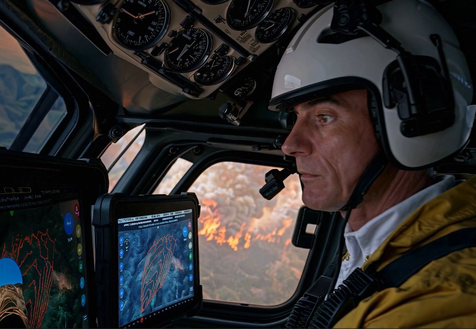
Air or ground, the same shared picture: the app rides with the response wherever it goes.
Because that picture is a timeline rather than a snapshot, an incident can be replayed. Scrub back through the
hours to see how the fire, the teams and the decisions unfolded, for a shift handover or a review afterwards.
From the command room to the last responder
WildCaster is one application with three roles, matched to how emergency organisations actually work. A
Manager oversees a wide region and sees every team and incident beneath them. A
Coordinator runs an incident and sees every team they direct. A Field Team
member works the line and sees their own data and their teammates' positions. The picture flows up and down that
chain, so the operations room and the fireline always work from the same truth.
Built for the edge
WildCaster is designed for the places wildfires happen, where infrastructure is thin and the network is the
first thing to fail. It runs on ordinary Android phones and tablets as well as desktop machines in the operations
room. The fire and smoke are modelled on the device itself, with no supercomputer and no cloud in the loop. The
map, terrain, weather and the layer of things to protect are carried on board, downloaded ahead of time for a
region, so the tool keeps working once the signal is gone. And teams share their picture with no server at all
when they are on the same local network. It behaves the same in a command centre on fibre and on a ridge with no
bars.
A record you can hand over
Every incident leaves a clean trail. WildCaster keeps a shared, timestamped log of the actions that matter,
ignitions, suppression, simulations, team movements and changing weather, replicated across the team so nothing
depends on one device surviving. When it is time to brief, hand over or report, it assembles a complete
Fire Spread Report: a self-contained document covering the situation, the operations, the
hour-by-hour impact on critical points, the fire-weather worst hour, the fuels involved, and a full record of the
engine settings used so any forecast can be reproduced. It reads as plain narrative, works fully offline, and is
ready to print or save as PDF.
Available
WildCaster is free for forest firefighters and fire brigades. Commercial licensing covers civil protection,
private industry and training organisations.