WildGeo is the data backbone of the Wildcaster ecosystem: the part you never see, and the part that makes
everything else possible. It gathers the environmental data a wildfire forecast depends on, prepares it, and
delivers it to every field device on a schedule.
When a crew opens WildCaster on a ridge with no signal and gets a forecast in seconds, it is because WildGeo put
the whole region on that device beforehand. It is built around a single idea: gather and prepare centrally,
once, so that every device can work alone, offline, anywhere.
Cut to your regionPacked in engine-native formCompact, fast to read
→
Delivered03
Downloaded once, resumableChecked for integritySmall scheduled updates
→
Every device04
Works fully offlineAlways currentOne picture for the whole team
Gathered and prepared centrally, once, so every device can work alone in the field.
ForestFire.app
What it gathers
WildGeo continuously pulls together the layers that decide how a fire behaves, each from an authoritative
European source.
Weather. The forecast is driven by the German Weather Service's ICON-EU numerical model,
refreshed four times a day in step with the model's own runs. WildGeo takes wind, temperature and humidity out
to 48 hours, together with the upper-air conditions the smoke model needs, and converts them into a form the
engine reads directly.
Terrain and fuels. Elevation, slope, aspect and a map of fuel types, described with the
internationally standard Scott and Burgan and Anderson fuel models, define the ground the fire moves across.
These are prepared once for a region and carried on every device.
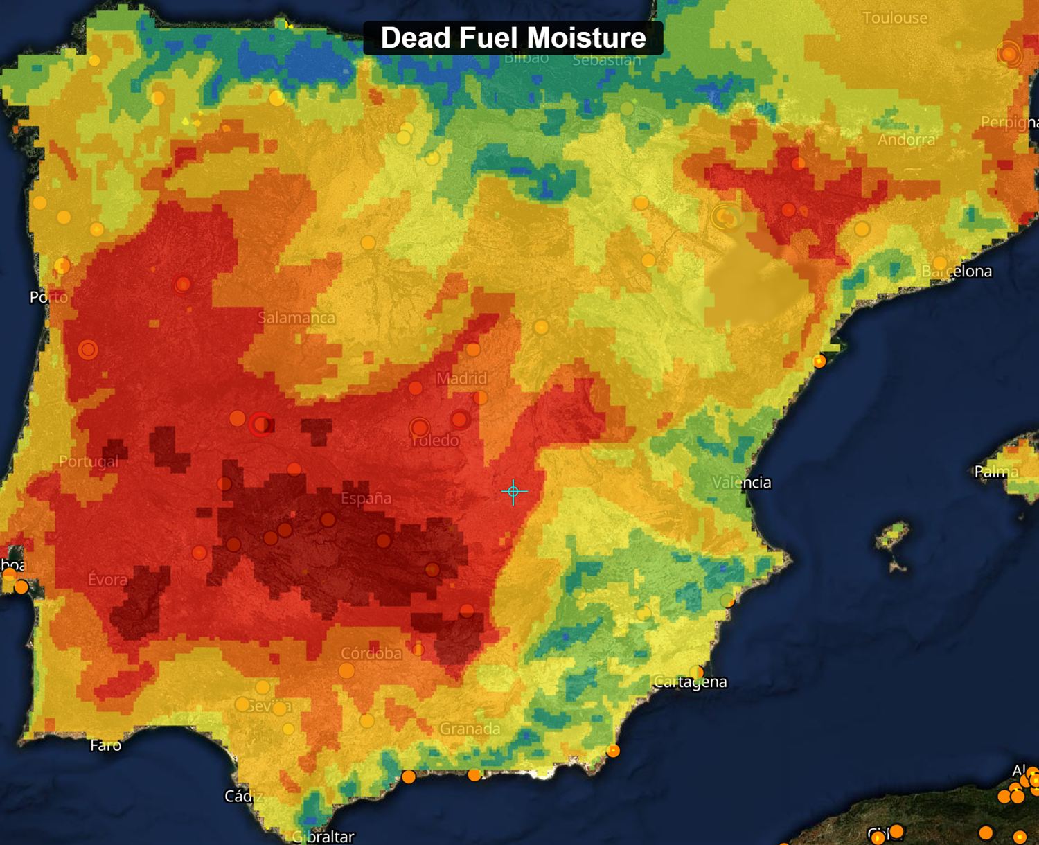
Fuel moisture. From the weather it delivers, the system builds a live picture of how dry the
fine dead fuels are, the single factor that most often decides whether an ember catches hold.
Dead fuel moisture across a whole region: from moist (blue) to critically dry (deep red), refreshed with every weather run.
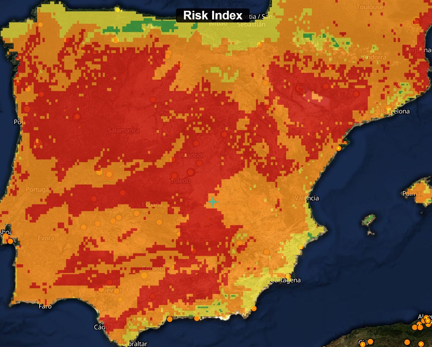
Fire-weather and risk. WildGeo folds in the European fire-weather index from the Copernicus
Emergency Management Service and EFFIS, the national fire-risk maps from Spain's AEMET, and the Mediterranean
fire-risk product from EUMETSAT's LSA-SAF, so the danger picture on the map reflects official guidance.
The fire-risk index, from low (green) to extreme (red), across the whole territory at a glance.
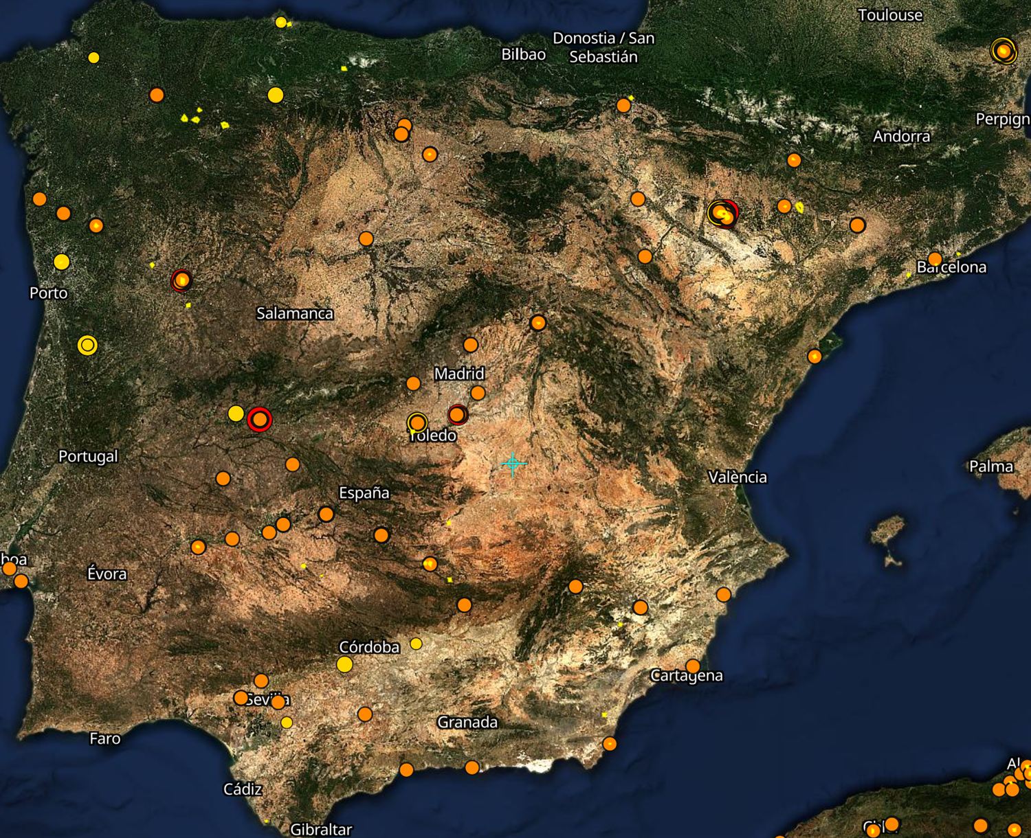
Live fire detection. Several times a day, WildGeo pulls the latest satellite fire detections
from NASA's FIRMS service, spanning the VIIRS instruments on the Suomi-NPP, NOAA-20 and NOAA-21 satellites and
the MODIS instruments on Aqua and Terra, alongside the active fires and burnt-area perimeters from EFFIS.
Live satellite fire detections from the VIIRS and MODIS instruments, refreshed through the day.
Imagery. High-resolution basemaps come from the EOX Sentinel-2 Cloudless mosaic and the
European Environment Agency's very-high-resolution imagery, so the ground beneath the fire is shown in real
detail.
How it prepares the data
Raw weather and satellite data is heavy and slow to work with. WildGeo does the hard part centrally, so the
device never has to. Each region, a geozone, is cut out of the pan-European data and written into formats built
for speed: terrain as a tiled binary the engine can read piece by piece with no decompression, weather as a
compact cube already in the engine's own units, and imagery as self-contained map files. Everything is keyed to
the geozone, so a whole team working the same area shares one prepared bundle instead of each downloading their
own.
How it delivers
WildGeo builds centrally and delivers automatically. A device activates with its licence, learns the bounds of
its geozone, and downloads the region's bundle once, over resumable transfers that survive a dropped connection
and are checked with a cryptographic hash so nothing arrives corrupt. From then on it simply asks for what has
changed: fresh weather four times a day, new fire detections and risk maps through the day, pulled as small
updates rather than full re-downloads. When there is no connection at all, the device keeps working from what it
already holds.
Why it matters
This is what lets the rest of the ecosystem run at the edge. Because WildGeo prepares everything centrally and
keeps a single authoritative copy, every device in the field sees the same, current picture. And because it
packages that picture for offline use, the forecast keeps working exactly where a wildfire takes the network
away.
WildGeo is built on Europe's public space investment. Its data comes from the Copernicus programme
and the EFFIS European fire information system, its imagery from Sentinel and the European Environment
Agency, and its forecasts from Europe's weather services and EUMETSAT. Field positioning across the
ecosystem draws on Europe's own Galileo and EGNOS satellite navigation. As an ESA-backed project,
WildGeo turns that investment into direct operational value for firefighters on the ground.