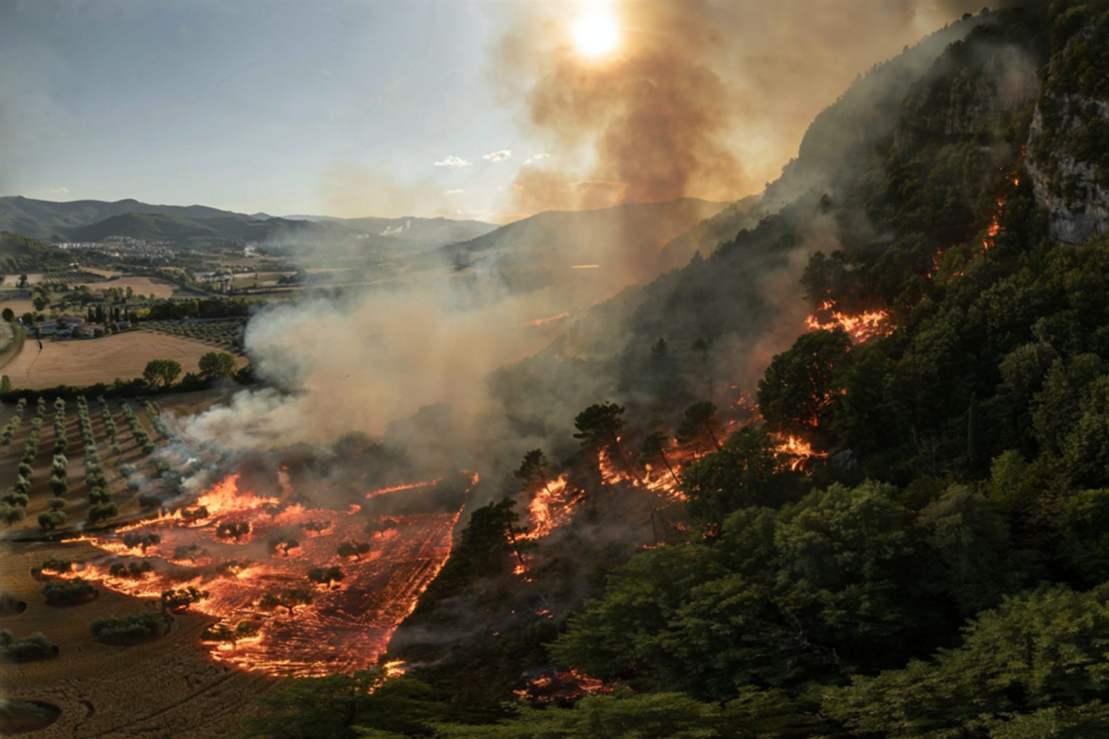
WildEngine is the fire and smoke nowcasting core of the Wildcaster ecosystem. It computes a full
24-hour forecast of a wildfire's behaviour in one to three seconds, entirely on the device it runs
on, with no connection to any network and no specialist equipment.
Historically, a wildfire behaviour forecast was produced in a command centre or a research institution,
on powerful computers, by specialist analysts, and reached the field only if time and connectivity
allowed. WildEngine removes that dependency. It is a nowcasting engine: where a
conventional forecast is produced at a distance and describes the days ahead, a nowcast is an immediate,
short-range projection built from the conditions happening right now, answering what this fire, in this
wind and on this ground, will do over the coming hours, computed on the spot.
Two properties make this matter operationally. The first is raw speed: a full day of fire spread computed
in seconds keeps the forecast in step with the fire rather than behind it. The second, and for an
organisation arguably the more important, is that it runs fully offline. Because the engine needs no
servers, no connectivity and no specialist infrastructure, the same simulation that once belonged to
command centres can be placed in the hands of everyone at the same time, from the civil-protection
director shaping the operation to the crew leader on the line. It democratises access to fire intelligence.
Simulate complex fire scenarios
On deviceFully offline1 to 3 seconds
Model inputs01
TerrainDEM, Slope & AspectWeatherWind, Temperature, MoistureFuelsLand cover, Models, Moisturefrom Copernicus, ESA and VIIRS / MODIS space data
Rate of spread (ROS)Elliptical growthCrown fireSpottingPyroconvectionFront merging
→
Impact forecast04
Affected critical points per hourBurnt-surface per typeDynamic hourly nowcast
How WildEngine turns live inputs into a tactical nowcast, on the device, in seconds.
ForestFire.app
What WildEngine does
Every fire is a conversation between four things, and the engine follows all of them at once: the
fuel on the ground, from cured grass that carries fire quickly to heavy timber and slash
that burn long and hot; the land, since fire runs uphill far faster than it backs downhill
and funnels through saddles and drainages; the weather, and above all the wind, followed
hour by hour across the day ahead; and the fire itself, meaning where it is at this moment,
which is the starting line from which the engine grows the fire forward in time.
The data that feeds these calculations comes from Europe's space and Earth-observation infrastructure. The
fuels and land cover, the terrain, and the weather that drives the forecast are derived from Copernicus
services and other European Space Agency resources, while active-fire detection draws on satellite hotspot
data from instruments such as VIIRS and MODIS. This grounding in continuously updated space data lets the
engine begin from a realistic picture of the landscape and the fire across its whole area of operation.
From these ingredients WildEngine advances the fire across the landscape and returns answers a tactical team can act on directly:
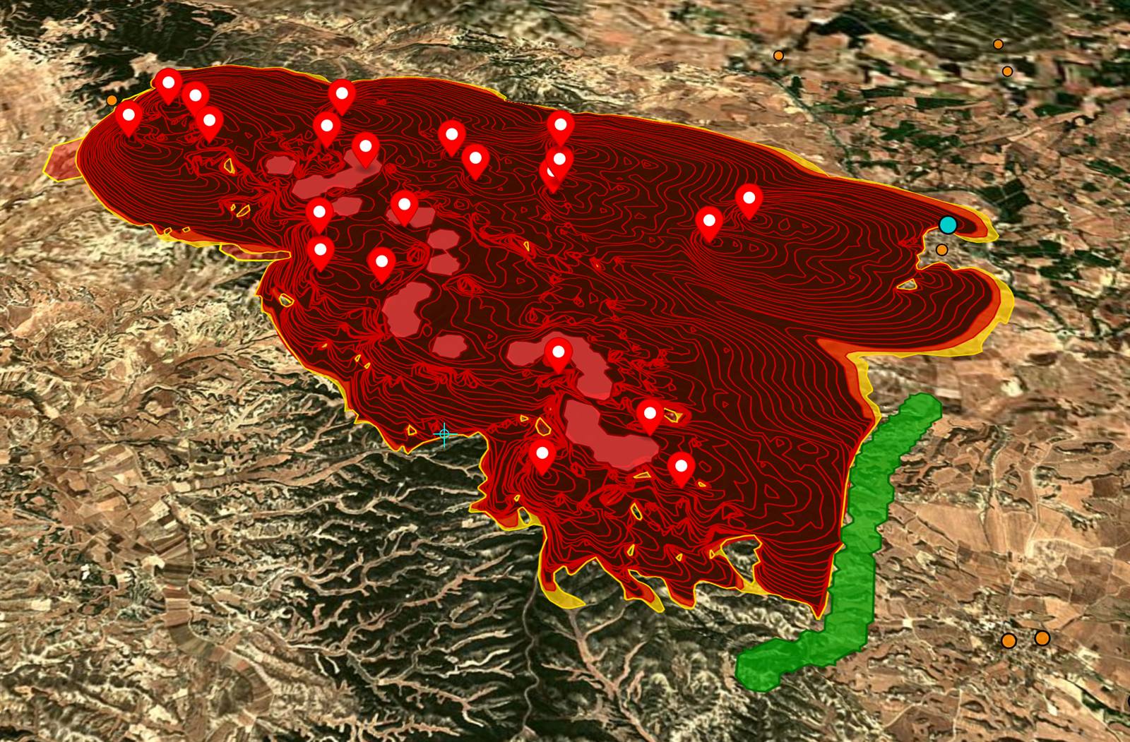
Where the fire will be, as a sequence of hourly perimeters that show the timing as well as the footprint: when the head reaches a road, when it threatens a settlement, and how much time you genuinely have.
How fast and how hard it is burning along each part of its edge, distinguishing a flank you can hold from a head you cannot.
When it climbs into the canopy and becomes a crown fire, the transition that changes everything about how the fire is fought.
Where it may jump, projecting the wind-driven embers that start new fires ahead of the front and outflank crews.
It is complete in the sense that counts operationally, modelling the full range of fire behaviour, surface,
crown and spotting, across every fuel type, rather than a single simplified case. And because everything it
needs is held on the device, it keeps working once connectivity is lost, which is the normal condition where
fires happen.
Fire propagation: simulated perimeter and hourly spread contours, with affected critical points.
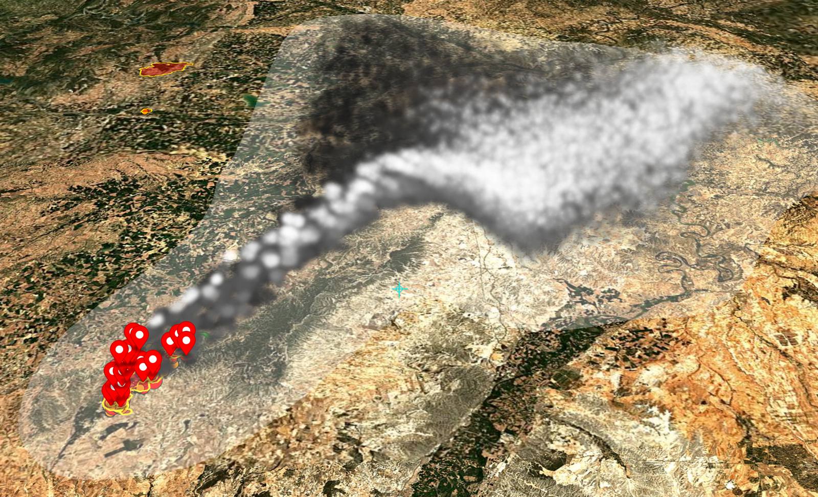
When the active phase eases, the same engine turns to a threat that reaches far beyond the fireline, into
towns and along highways many kilometres away: the smoke. WildEngine simulates the plume drifting and
spreading through the atmosphere and maps the resulting air quality on the ground, using the same
colour-coded health categories the public already recognises from air-quality alerts. This is a deeper and
heavier calculation than the fire forecast, and it is built for the command post and the duty office rather
than the split-second call on the line, answering the questions that drive evacuations and public-health
warnings: which neighbourhoods are about to be affected, which roads remain usable, and where and when people
should be moved or told to shelter.
Smoke dispersion: the modelled plume drifting downwind from the fire.
The science underneath
Beneath the speed sits a well-established body of fire and atmospheric science, implemented in full and
checked against the original studies. What follows names the specific models WildEngine uses and links to the
source literature, so the science can be verified rather than taken on trust.
Surface fire spread
The rate at which a fire advances through a given fuel under a given wind and slope follows the semi-empirical
spread equation of
Rothermel (1972),
with the computational refinements of Frank Albini (1976) that made it practical to evaluate. Its accuracy
depends on an honest description of the fuel, so WildEngine drives it with the two internationally standard
fuel-model sets: the original thirteen of Anderson (1982) and the expanded forty of
Scott and Burgan (2005),
which between them describe grass, shrub, timber-litter and slash fuels, and the distinct way each ignites,
carries fire and burns out.
Crown fire
The passage from a surface fire to a fire running through the canopy is among the most dangerous transitions on
any incident, and WildEngine models it explicitly. It uses the initiation criteria of
Van Wagner (1977)
to determine when a surface fire has enough intensity to ignite the crowns, the active-crown rate-of-spread
model of
Cruz, Alexander and Wakimoto (2005)
to predict how fast it then travels, and the surface-to-crown linkage of
Scott and Reinhardt (2001)
to handle the transition between the two regimes.
Ember spotting
Long-range spotting, in which embers are lofted downwind to start new fires ahead of the front, is treated as
what it physically is: a matter of probability resolved many thousands of times over. WildEngine builds on the
pioneering firebrand-transport model of Frank Albini (1979), together with the crosswind-scatter formulation of
Himoto and Tanaka (2005), the short-grass ignition-probability curves of Schroeder (1969) and the flight-survival
modelling of Perryman (2012). It launches a large population of virtual embers, carries each on the wind, and
tests whether it survives its flight and finds receptive fuel where it lands.
Fire-front propagation
To turn this physics into a clean, advancing perimeter, WildEngine represents the fire's edge with the level-set
method introduced by
Osher and Sethian (1988)
and adapted to wildland fire by
Mallet, Keyes and Fendell (2009).
This front-based approach to fire simulation has a rich research lineage, including the influential front-tracking
and coupled fire-atmosphere modelling of
Filippi and colleagues (2009);
WildEngine's implementation is its own, but it shares that tradition's central insight of focusing computation on
the moving fire front. A narrow-band scheme confines the calculation to the immediate vicinity of the live edge,
which is a large part of why the perimeters behave like real fires and compute so quickly.
Fuel moisture
All of the above depends on knowing how dry the fine fuels are, since the moisture in dead grass and twigs
decides whether an ember dies or takes hold. WildEngine estimates this continuously using the dead-fuel-moisture
science of Fosberg and Deeming (1971), calibrated for the hot, dry, wind-driven conditions of the Mediterranean
fire season.
Smoke dispersion
The smoke simulation is a substantial piece of atmospheric physics. Instead of smearing smoke across a map,
WildEngine follows it as a swarm of individual particles, each carried by the wind and scattered by turbulence,
an approach known as Lagrangian stochastic dispersion that is also used to forecast volcanic ash and radiological
plumes. Every particle obeys the well-mixed condition of
Thomson (1987),
the theoretical requirement that keeps the modelled smoke physically consistent with the turbulence it moves
through, with the turbulence statistics themselves taken from Hanna (1982). Because the atmosphere behaves very
differently across the day, the model treats the daytime convective boundary layer with the skewed-turbulence
scheme of
Cassiani, Stohl and Brioude (2015),
and grounds the near-surface wind and stability in Monin-Obukhov similarity theory. The height to which the fire's
own heat drives the plume is set by the injection-height model of
Sofiev, Ermakova and Vankevich (2012),
building on the classical buoyant-plume work of Briggs (1975, 1984). Smoke is removed from the air realistically as
particles settle under gravity and as rain scavenges them below cloud, following the size-resolved scavenging
parameterisation of
Wang, Zhang and Moran (2014).
The result is a ground-level map of fine-particle pollution, the PM2.5 fraction that matters most for human health,
sorted into the standard air-quality bands and driven directly by the live fire through the biomass-burning
emission factors of
Andreae (2019).
The implementation
Building on this leading science, WildEngine contributes a tactical, robust implementation of it: one that runs
the complete chain, surface fire, crown fire, spotting and smoke, in seconds, offline, on ordinary handheld
hardware. That is achieved through a set of proprietary optimisations that concentrate the computation only on the
ground the fire can actually reach and follow only its live edge, delivering research-grade fire and smoke modelling
at field speed with no supporting infrastructure. This is what places a genuine nowcast in the hands of every
responder, from the operations room to the fireline, wherever the fire happens to be.
References
Cassiani, M., Stohl, A., Brioude, J. (2015). Lagrangian stochastic modelling of dispersion in the convective boundary layer with skewed turbulence conditions and a vertical density gradient. Boundary-Layer Meteorology 154, 367-390. doi:10.1007/s10546-014-9976-5
Andreae, M. O. (2019). Emission of trace gases and aerosols from biomass burning - an updated assessment. Atmos. Chem. Phys. 19, 8523-8546. doi:10.5194/acp-19-8523-2019
Sofiev, M., Ermakova, T., Vankevich, R. (2012). Evaluation of the smoke-injection height from wild-land fires using remote-sensing data. Atmos. Chem. Phys. 12, 1995-2006. doi:10.5194/acp-12-1995-2012
Wang, X., Zhang, L., Moran, M. D. (2014). Bulk or modal parameterizations for below-cloud scavenging of fine, coarse, and giant particles. J. Adv. Model. Earth Syst. 6, 1301-1310. doi:10.1002/2014MS000392
Cruz, M. G., Alexander, M. E., Wakimoto, R. H. (2005). Development and testing of models for predicting crown fire rate of spread in conifer forest stands. Can. J. For. Res. 35, 1626-1639. doi:10.1139/x05-085
Mallet, V., Keyes, D. E., Fendell, F. E. (2009). Modeling wildland fire propagation with level set methods. Computers & Mathematics with Applications 57, 1089-1101. doi:10.1016/j.camwa.2008.10.089
Filippi, J.-B., Bosseur, F., Mari, C., et al. (2009). Coupled atmosphere-wildland fire modelling. J. Adv. Model. Earth Syst. 1, 11. doi:10.3894/JAMES.2009.1.11
Rothermel, R. C. (1972). A mathematical model for predicting fire spread in wildland fuels. USDA Forest Service Res. Pap. INT-115. treesearch/32533
Van Wagner, C. E. (1977). Conditions for the start and spread of crown fire. Can. J. For. Res. 7, 23-34. doi:10.1139/x77-004
Scott, J. H., Reinhardt, E. D. (2001). Assessing crown fire potential. USDA Forest Service RMRS-RP-29. treesearch/4623
Scott, J. H., Burgan, R. E. (2005). Standard fire behavior fuel models. USDA Forest Service RMRS-GTR-153. treesearch/9521
Osher, S., Sethian, J. A. (1988). Fronts propagating with curvature-dependent speed. J. Comput. Phys. 79, 12-49. doi:10.1016/0021-9991(88)90002-2
Thomson, D. J. (1987). Criteria for the selection of stochastic models of particle trajectories in turbulent flows. J. Fluid Mech. 180, 529-556. doi:10.1017/S0022112087001940
Also cited: Anderson (1982) INT-122; Albini (1976) INT-30 and Albini (1979) INT-56; Schroeder (1969); Himoto & Tanaka (2005); Perryman (2012); Fosberg & Deeming (1971) RM-207; Hanna (1982); Briggs (1975, 1984).
ForestFire.app
Available for integration
WildEngine is available as a licensed component for civil-protection platforms, infrastructure and transport
operators, and research institutions that need fast, complete, on-device fire and smoke nowcasting within their
own systems.